Translations:ON ARRIVAL/3/en-gb
GET YOUR BEARINGS
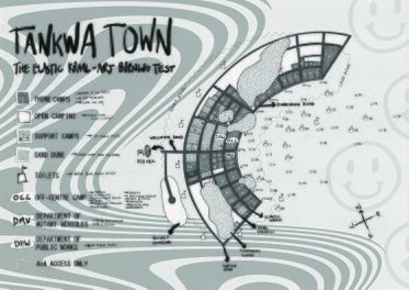
Tankwa Town is usually laid out in a horseshoe shape, with two projecting ‘horns’ at the top, and a long tail that stretches down. In our new home at Quaggafontein it's likely that the design of Tankwa Town will be quite different and change from year to year as we grow and explore our new surroundings. The centre of Tankwa Town is always called the Binnekring (not the Playa!), and it’s where a lot of the art is placed.
The road that fronts this central space is called the 'Binnekring Road', and the streets that radiate off the Binnekring are numbered like the hours on a clock, from 1-ish through to 11-ish. This way, once you’ve found your camping spot for the event, you’ll have an address if you get lost. For example, you could be living at ‘Buitekring and 3:30-ish’. We have signs and street lamps to help you figure out where the hell you are. The roads are also named in alphabetical order radiating outwards from Binnekring. These names do change every year according to the theme of that year (except for Binnekring Rd, Buitekring Rd, Lady Davina Boulevard, Stofadil Rd, Nansen Street and the radials.)
