GETTING THERE & DIRECTIONS: Difference between revisions
Marked this version for translation Tag: Reverted |
|||
| (18 intermediate revisions by 7 users not shown) | |||
| Line 1: | Line 1: | ||
'''Roads update 9th April 2025 from Tove.''' | |||
There has been yet more rain ahead of the event, which is making the R355 more unpredictable. Around the Padstal, the road has been washed away (slightly), so some sudden holes and sharp rocks have appeared. When coming from the Ceres side, where they had left piles of sand by the side of the road for repairs, these have now washed onto the road and it's very slippery at times. Soft new sand combined with rain makes the car feel almost self-driving ... which it is not. Please take extra care when travelling to AfrikaBurn at this time. | |||
===== '''Roads update: 26th March 2025 from Dewey''' ===== | |||
The | [[File:Map to Quagga detail.jpg|alt=Detail map|thumb|411x411px|The light blue lines are the available routes but lead through private farms, these routes are not public and have many locked gates. Google maps chooses the shortest route to AfrikaBurn, but you need to stay on the R355 until you see the sign for the Tankwa Karoo National Park, Middelpos (R354) Sutherland.]]After the recent rains, our smooth Tankwa R355 highway is no more. The first section of the R355, as always, is bad, now slightly worse. After recent rains in the Doring catchment area, around the Padstal and beyond, there are bad patches to slow down where there was standing water. The Middelpos road is just more corrugated than before, which sounds impossible because it was very fokken corrugated before the rain. The Ongeluks rivers seem to have not caught much rain at all. | ||
'''The tunes are pumping, the vibes are a'flowing and the world has never looked more beautiful as you and your mates/soulmates/lovers and cousins are finally on the road after hours of car [[wikipedia:Tetris|tetris]] and some tears over the splash pool that simply couldn't fit in.''' But this is not the part where you light up / crack open a favourite and let loose. Lives have been lost on the R355. Pull on some serious adult pants and PLAN WELL AHEAD so you have loads of time to take it super slow once you depart from otherwise tame roads and tackle the R355. Besides, tyres are expensive. | |||
The | [[File:ROAD 2024 v1.jpg|alt=Map to AfrikaBurn|left|thumb|385x385px|There are currently some significant road hazards just before you get to AfrikaBurn]] | ||
== RULE ONE: SLOW THE F*CK DOWN – keep to the safe speed limit of 70Km/h == | |||
Please bear in mind the R355 is a deceptive dirt road that has claimed many lives. Please drive calmly, even if you have a 4x4, and especially if you don’t. | |||
The last stretch of road is a narrow farm road – please be patient when arriving as there may be a queue. | |||
== RULE TWO: Don't follow the GPS coordinates == | |||
The GPS coordinates for the entrance are: '''32°28'57.5"S 19°53'51.4"E''' or type 'Quaggakop' into your GPS app - NOT Quaggafontein. '''BUT ... don't just punch these coordinates in as you may get routed through someone else's farm.''' | |||
Some GPS apps will take you to Ceres first then make you turn around back to Tankwa! Some experienced Burners trusted the GPS once and it took them on this extremely bizarre pass that was even worse than the Calvinia road. It was kak as... Well it was kak. Anything faster than 20 km/h would make their car vibrate like a de-sensitised road flattening vibrator. '''You have been warned!''' | |||
'''Don't click this link: https://goo.gl/maps/msYmxxgKT4ymsdYPA''' | |||
== RULE THREE: Don't get a lift with Ryan == | |||
< | == HOW TO SURVIVE THE R355: == | ||
'''<big><nowiki>#</nowiki>1TIP: STICK TO 70KM/H (or less) – and DO NOT OVERTAKE IF YOU CANNOT SEE AHEAD.</big>''' [[File:Route to Quagga.jpg|alt=N1 to Quaggafontein|thumb|Not all GPS are the same. Click to enlarge.|left|364x364px]] | |||
• Normal road safety rules apply, even to (and especially) RV’s and 4x4’s. Just because you drive a 5-litre 4x4 doesn’t mean your ass won’t roll and your tyres won’t get shredded. | |||
• Just because you drive a 5-litre 4x4 doesn’t mean your ass won’t roll and your tyres won’t get shredded. | |||
• We strongly recommend travelling in convoy if you need help changing a tyre. | |||
• We strongly recommend travelling in convoy. | |||
• Drive up during daylight hours – it’s much safer! | • Drive up during daylight hours – it’s much safer! | ||
• Don’t overload your vehicle. | • Don’t overload your vehicle. | ||
• Don’t speed - 70km/h is good, but if your vehicle is heavy, reduce speed to 50km/h or less.[[File:2009 shredded tyre.jpg|thumb|Not-so-Goodyear 2009. And nope, the road hasn't improved. |left|364x364px]] | |||
• Don’t speed - 70km/h is good, but if your vehicle is heavy, reduce speed to 50km/h or less | |||
• Drive at dawn - in the heat of midday, tyres heat up, which means your sidewalls/tyres puncture easier and the shale rock on the road fractures easier. Cooler tyres + cooler roads = less punctures and blowouts. | |||
• The R355 is one helluva lot of dirt road. It has some bad patches where sharp stones puncture sidewalls (yes, even the sidewalls of your Roadmuncher Desert Eagles), so please drive carefully and slowly. | |||
• | |||
• It’s tempting to feel like you’re almost there when you hit the dirt road – you aren’t. It takes about an hour and a half to cover the dirt section, which is the most treacherous part. We’re not kidding – observe the many stripped tyres alongside the road. | |||
• We’re not kidding – observe the many stripped tyres alongside the road. | |||
• Cellphone coverage is patchy along the dirt road. The last reliable signal is just before you pass through Karoopoort from the south, and at Bloukrans Pass from the north. | • Cellphone coverage is patchy along the dirt road. The last reliable signal is just before you pass through Karoopoort from the south, and at Bloukrans Pass from the north. | ||
• Enjoy the view. But if you stop on the dirt road, pull off to the side - and do not, under any circumstances, stop on a blind rise. | |||
• | == SAVING YOUR TYRES == | ||
[[File:R355 raul aragao.jpg|thumb|234x234px|Thanks to Raul Aragao for this picture of one of our warning lables]] | |||
== SAVING YOUR TYRES == | |||
It’s legend and fact: the R355 eats tyres for breakfast, lunch and supper. Here are some blowout avoidance tips: | It’s legend and fact: the R355 eats tyres for breakfast, lunch and supper. Here are some blowout avoidance tips: | ||
• Check your tyres and tyre pressures before you leave, make sure they are in good nick. | |||
• Check your tyres before you leave, make sure they are in good nick. | |||
• Keep your tyres inflated as per the manufacturer guidelines, so that the sidewalls of your tyres have less exposure to sharp stones | |||
• Keep your tyres | |||
• We know it’s a big ask - but try not to overload your vehicle. | |||
• We know it’s a big ask | |||
• Try NOT to cross over the stony ‘middle-mannetjie’ (middle path). In the same breath, don't hug the road too closely on the left either, as larger sharp stones are often flung from the road to gather there in packs. | |||
• | [[File:R355.jpg|thumb|233x233px|When we say the R355 eats tyres... we mean it]] | ||
• We recommend that you take two spares with you as well as a tyre repair kit. Take a tip from the local farmers – carry snotplugs and a compressor (or tyre pump / Tyre Weld). | |||
• Keep your spare tyres accessible when packing. | |||
• | |||
• Our crew don’t patrol the R355 and are not able to provide assistance outside of the event. | |||
• | |||
• There is a tyre repair station at Tankwa Tented Camp or the Tankwa Padstal folk will usually try to help. | |||
• There is a tyre repair station at Tankwa Tented Camp. | |||
• Respect donkey carts and animals - donkeys do not move out of the way! | • Respect donkey carts and animals - donkeys do not move out of the way! | ||
• When passing, slow down to reduce rocks and dust, don't cut straight back into the car in front of you as you may kick stones up into their windscreen. | |||
• When passing, slow down to reduce rocks and dust | |||
=== '''EXTREMELY IMPORTANT: DO NOT OVERTAKE WHEN THE ROAD AHEAD IS OBSCURED BY DUST.''' === | |||
Please understand – this is lethal, fatal, dangerous behaviour. DON’T DO IT. | This has been the cause of [https://www.afrikaburn.org/binnekringblog/dont-drive-like-a-dick/ fatal head-on collisions in the past]. Please understand – this is lethal, fatal, dangerous behaviour. '''PLEASE DON’T DO IT.''' | ||
== <u>DIRECTIONS TO QUAGGAFONTEIN</u> == | == <u>DIRECTIONS TO QUAGGAFONTEIN</u> == | ||
[[File:Map to get to Quaggafontein & AfrikaBurn.jpg|alt=map to drive from cape town to quaggafontein|left|thumb|493x493px|Directions from Cape Town. [https://quaggapedia.afrikaburn.com/images/6/66/Map_to_get_to_Quaggafontein_%26_AfrikaBurn.jpg Click for high res image.]]] | |||
== FROM CAPE TOWN == | |||
Aweh! Rad you could make it bru! | Aweh! Rad you could make it bru! | ||
Take the N1 North, passing Paarl, Worcester and De Doorns. 10km before you reach Touwsrivier, 160km from Cape Town, take the LEFT onto the R46, towards Ceres. If you need to fill up on fuel, do so – Worcester or Touwsrivier are your last chances. | Take the N1 North, passing Paarl, Worcester and De Doorns. 10km before you reach Touwsrivier, 160km from Cape Town, take the LEFT onto the R46, towards Ceres. If you need to fill up on fuel, do so – Worcester or Touwsrivier are your last chances. | ||
This road continues for approximately 40km and ends in a T-junction. At the T-junction turn RIGHT onto the tyre-munching R355 towards Calvinia and Sutherland. Approximately 100m on, you’ll hit the dirt. | This road continues for approximately 40km and ends in a T-junction. At the T-junction turn RIGHT onto the tyre-munching R355 towards Calvinia and Sutherland. Approximately 100m on, you’ll hit the dirt. | ||
SLOW DOWN. | SLOW DOWN. | ||
You brought a spare wheel, right? Good. Oh, you brought two? Smart move. | You brought a spare wheel, right? Good. Oh, you brought two? Smart move. | ||
This stretch of road is dangerous. Like psycho-pitbull-with-a-hangover dangerous. DO NOT DRIVE AT HIGH SPEED. | |||
This stretch of road is dangerous. Like psycho-pitbull-with-a- hangover dangerous. DO NOT DRIVE AT HIGH SPEED. | |||
It’s a long road - take in the view, read the signs. | It’s a long road - take in the view, read the signs. | ||
Round about now, you lose cellphone signal (did you download a podcast from [[RADIO FREE TANKWA|Radio Free Tankwa]]?). Switch it off and forget about it. Goodbye telecommunication, hello real communication! | |||
Round about now, you lose cellphone signal (did you download a podcast from Radio Free Tankwa?). Switch it off and forget about it. Goodbye telecommunication, hello real communication! | |||
Stay on the R355 towards Calvinia and the Tankwa Padstal, you'll see a giant crashed flying saucer just outside it. The Padstal is a great place to stretch your feet and the last WiFi you'll have for a while. Once you're fully refreshed, get back on the R355 heading north towards the Tankwa Karoo National Park. | |||
Stay on the R355 towards Calvinia and the Tankwa Padstal, you'll see a giant crashed flying saucer just outside it. The Padstal is a great place to stretch your feet and the last | |||
About 22km from the Tankwa Padstal, you'll see a turn off to your right, that is also signposted "Tankwa Karoo National Park". Take this turning that heads East towards Quaggafontein. | About 22km from the Tankwa Padstal, you'll see a turn off to your right, that is also signposted "Tankwa Karoo National Park". Take this turning that heads East towards Quaggafontein. | ||
Continue along this road for about 33km and then the entrance to Quaggafontein (and AfrikaBurn) will be on your right-hand side. | |||
Continue along this road for about 33km and then the entrance to Quaggafontein (and AfrikaBurn) will be on your right hand side. | |||
It’s a rough road, so take it easy - you’re nearly there. | It’s a rough road, so take it easy - you’re nearly there. | ||
As you go through the gate, you’ll come to Die Hek, the gate to Tankwa Town, and Box Office. Here you will be checked in, and your tickets scanned. | |||
As you go through the gate you’ll come to Die Hek, the gate to Tankwa Town, and Box Office. Here you will be checked in, and your tickets scanned. | |||
Move along to the Greeting Station. Take a deep breath. Step through the portal. | Move along to the Greeting Station. Take a deep breath. Step through the portal. | ||
If you’re a Virgin, ring the virgin bell! | |||
If you’re a Virgin, ring the bell! | |||
WELCOME! | WELCOME! | ||
== FROM JOHANNESBURG == | == FROM JOHANNESBURG == | ||
From Jozi? Huzzit, | From Jozi? Huzzit, China! | ||
Take the N1 South to Bloemfontein/Cape Town. Stay on the N1 through Colesburg, Hanover and Richmond. | Take the N1 South to Bloemfontein/Cape Town. Stay on the N1 through Colesburg, Hanover and Richmond. | ||
From Richmond travel 64km on the N1 and turn right onto the R63 to Victoria West. Travel on the R63 through Victoria West and follow the road and signs to Calvinia. | From Richmond travel 64km on the N1 and turn right onto the R63 to Victoria West. Travel on the R63 through Victoria West and follow the road and signs to Calvinia. | ||
'''Note:''' Do not attempt to go via the R354 (Middlepos) road. It is in an extremely bad state and will take you 8 hours to do the 180 km or so to Quaggafontein. | '''Note:''' Do not attempt to go via the R354 (Middlepos) road. It is in an extremely bad state and will take you 8 hours to do the 180 km or so to Quaggafontein. | ||
Also take note: This is the last time you will have phone signal until you get back to this spot - this includes at the event. | |||
Calvinia is the last place where you can get supplies (water, gas, petrol, etc.), so if you need them, get them. There are no shops after Calvinia. | Calvinia is the last place where you can get supplies (water, gas, petrol, etc.), so if you need them, get them. There are no shops after Calvinia. | ||
'''Drive through Calvinia and about 2km outside of town you’ll see a sign ‘Ceres R355’. Turn left here onto the gravel road to Ceres. Stick to the R355 until you get the turnoff to the Tankwa Karoo National park (About 50 or so km from the Calvinia side) you will see a board on the roadside saying Calvinia-Ceres - turn left at that turn. This is the shortest road to take, it does have a couple of sections that has been somewhat washed away but it is manageable if you take it slowly.''' | |||
'''Drive through Calvinia and about 2km outside of town you’ll see a sign ‘Ceres R355’. Turn left here onto the gravel road to Ceres. Stick to the R355 until you get the turnoff to the Tankwa Karoo National park (About 50 or so km from the Calvinia side) you will see a board on the roadside saying Calvinia-Ceres - turn left at that turn. This is the shortest | |||
Do NOT drive faster that 70km per hour under any circumstances, or in any vehicle, at any time along this gravel road! | Do NOT drive faster that 70km per hour under any circumstances, or in any vehicle, at any time along this gravel road! | ||
Continue along this road for about 90km and then the entrance to Quaggafontein (and AfrikaBurn) will be on your left-hand side. | |||
Continue along this road for about 90km and then the entrance to Quaggafontein (and AfrikaBurn) will be on your left hand side. | |||
==== '''Alternative route 1:''' Continue to travel carefully along the R355 for approximately 140km. ''Do not turn off, but rather follow the R355 down past Stonehenge/Tankwa Tented Camp'' ==== | |||
Watch up ahead for a Junction with a road to the left that is also signposted "Tankwa Karoo National Park". Take this turning that heads East towards Quaggafontein. | Watch up ahead for a Junction with a road to the left that is also signposted "Tankwa Karoo National Park". Take this turning that heads East towards Quaggafontein. | ||
Continue along this road for about 33km and then the entrance to Quaggafontein (and AfrikaBurn) will be on your right-hand side. You’re almost there boet! | |||
Continue along this road for about 33km and then the entrance to Quaggafontein (and AfrikaBurn) will be on your right hand side. You’re almost there boet! | |||
=== | ==== '''Alternative route 2:''' You can also drive all the way down the N1 to Touws River and then turn right back up towards the R355 at Touws River and follow the Cape Town directions. ''<u>This is the current preferred route for our creative crews from Joburg</u>'' ==== | ||
Drive about 5km SLOWLY along the entrance road. | Drive about 5km SLOWLY along the entrance road. | ||
Holy crap, you’re close now! Further along you’ll come to Die Hek, our event gate and Box Office | Holy crap, you’re close now! Further along you’ll come to Die Hek, our event gate and Box Office | ||
Move along to the Greeting Station. Take a deep breath. | Move along to the Greeting Station. Take a deep breath. | ||
Virgin? Welcome – ring the bell! | Virgin? Welcome – ring the bell! | ||
== VIA BLOEM == | == VIA BLOEM == | ||
Van Bloem af, chomma? Mooi so! | Van Bloem af, chomma? Mooi so! | ||
Take the N8 to Kimberley and then continue along the N12 to Victoria West. | Take the N8 to Kimberley and then continue along the N12 to Victoria West. | ||
Turn right into the R63 at Victoria West (T-junction), thereafter follow the directions listed above for Johannesburg from Victoria West onward. | Turn right into the R63 at Victoria West (T-junction), thereafter follow the directions listed above for Johannesburg from Victoria West onward. | ||
Again, from Bloem you can also just follow the N1 to Touws River (Alternative route 2). | |||
== FROM DURBAN == | == FROM DURBAN == | ||
From Durbs? Hundreds bru! | From Durbs? Hundreds bru! | ||
Take the N3 out of town, and head to Harrismith. | Take the N3 out of town, and head to Harrismith. | ||
At Harrismith, take the N5 via Bethlehem to Winberg, where you join the N1 and follow this to Bloemfontein. | At Harrismith, take the N5 via Bethlehem to Winberg, where you join the N1 and follow this to Bloemfontein. | ||
Thereafter follow the directions listed for Bloemfontein. | Thereafter follow the directions listed for Bloemfontein. | ||
Click here for [[Print Friendly Directions.]] | |||
Also see: [[MAPS|Maps.]] | Also see: [[MAPS|Maps.]] | ||
Latest revision as of 10:14, 9 April 2025
Roads update 9th April 2025 from Tove.
There has been yet more rain ahead of the event, which is making the R355 more unpredictable. Around the Padstal, the road has been washed away (slightly), so some sudden holes and sharp rocks have appeared. When coming from the Ceres side, where they had left piles of sand by the side of the road for repairs, these have now washed onto the road and it's very slippery at times. Soft new sand combined with rain makes the car feel almost self-driving ... which it is not. Please take extra care when travelling to AfrikaBurn at this time.
Roads update: 26th March 2025 from Dewey
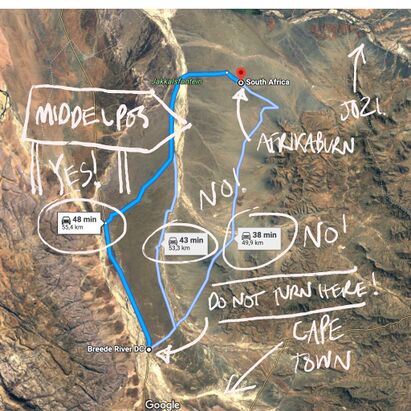
After the recent rains, our smooth Tankwa R355 highway is no more. The first section of the R355, as always, is bad, now slightly worse. After recent rains in the Doring catchment area, around the Padstal and beyond, there are bad patches to slow down where there was standing water. The Middelpos road is just more corrugated than before, which sounds impossible because it was very fokken corrugated before the rain. The Ongeluks rivers seem to have not caught much rain at all.
The tunes are pumping, the vibes are a'flowing and the world has never looked more beautiful as you and your mates/soulmates/lovers and cousins are finally on the road after hours of car tetris and some tears over the splash pool that simply couldn't fit in. But this is not the part where you light up / crack open a favourite and let loose. Lives have been lost on the R355. Pull on some serious adult pants and PLAN WELL AHEAD so you have loads of time to take it super slow once you depart from otherwise tame roads and tackle the R355. Besides, tyres are expensive.
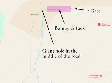
RULE ONE: SLOW THE F*CK DOWN – keep to the safe speed limit of 70Km/h
Please bear in mind the R355 is a deceptive dirt road that has claimed many lives. Please drive calmly, even if you have a 4x4, and especially if you don’t.
The last stretch of road is a narrow farm road – please be patient when arriving as there may be a queue.
RULE TWO: Don't follow the GPS coordinates
The GPS coordinates for the entrance are: 32°28'57.5"S 19°53'51.4"E or type 'Quaggakop' into your GPS app - NOT Quaggafontein. BUT ... don't just punch these coordinates in as you may get routed through someone else's farm.
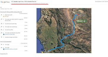
Some GPS apps will take you to Ceres first then make you turn around back to Tankwa! Some experienced Burners trusted the GPS once and it took them on this extremely bizarre pass that was even worse than the Calvinia road. It was kak as... Well it was kak. Anything faster than 20 km/h would make their car vibrate like a de-sensitised road flattening vibrator. You have been warned!
Don't click this link: https://goo.gl/maps/msYmxxgKT4ymsdYPA
RULE THREE: Don't get a lift with Ryan
HOW TO SURVIVE THE R355:
#1TIP: STICK TO 70KM/H (or less) – and DO NOT OVERTAKE IF YOU CANNOT SEE AHEAD.
• Normal road safety rules apply, even to (and especially) RV’s and 4x4’s. Just because you drive a 5-litre 4x4 doesn’t mean your ass won’t roll and your tyres won’t get shredded.
• We strongly recommend travelling in convoy if you need help changing a tyre.
• Drive up during daylight hours – it’s much safer!
• Don’t overload your vehicle.
• Don’t speed - 70km/h is good, but if your vehicle is heavy, reduce speed to 50km/h or less.
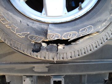
• Drive at dawn - in the heat of midday, tyres heat up, which means your sidewalls/tyres puncture easier and the shale rock on the road fractures easier. Cooler tyres + cooler roads = less punctures and blowouts.
• The R355 is one helluva lot of dirt road. It has some bad patches where sharp stones puncture sidewalls (yes, even the sidewalls of your Roadmuncher Desert Eagles), so please drive carefully and slowly.
• It’s tempting to feel like you’re almost there when you hit the dirt road – you aren’t. It takes about an hour and a half to cover the dirt section, which is the most treacherous part. We’re not kidding – observe the many stripped tyres alongside the road.
• Cellphone coverage is patchy along the dirt road. The last reliable signal is just before you pass through Karoopoort from the south, and at Bloukrans Pass from the north.
• Enjoy the view. But if you stop on the dirt road, pull off to the side - and do not, under any circumstances, stop on a blind rise.
SAVING YOUR TYRES
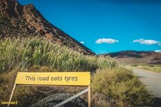
It’s legend and fact: the R355 eats tyres for breakfast, lunch and supper. Here are some blowout avoidance tips:
• Check your tyres and tyre pressures before you leave, make sure they are in good nick.
• Keep your tyres inflated as per the manufacturer guidelines, so that the sidewalls of your tyres have less exposure to sharp stones
• We know it’s a big ask - but try not to overload your vehicle.
• Try NOT to cross over the stony ‘middle-mannetjie’ (middle path). In the same breath, don't hug the road too closely on the left either, as larger sharp stones are often flung from the road to gather there in packs.
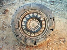
• We recommend that you take two spares with you as well as a tyre repair kit. Take a tip from the local farmers – carry snotplugs and a compressor (or tyre pump / Tyre Weld).
• Keep your spare tyres accessible when packing.
• Our crew don’t patrol the R355 and are not able to provide assistance outside of the event.
• There is a tyre repair station at Tankwa Tented Camp or the Tankwa Padstal folk will usually try to help.
• Respect donkey carts and animals - donkeys do not move out of the way!
• When passing, slow down to reduce rocks and dust, don't cut straight back into the car in front of you as you may kick stones up into their windscreen.
EXTREMELY IMPORTANT: DO NOT OVERTAKE WHEN THE ROAD AHEAD IS OBSCURED BY DUST.
This has been the cause of fatal head-on collisions in the past. Please understand – this is lethal, fatal, dangerous behaviour. PLEASE DON’T DO IT.
DIRECTIONS TO QUAGGAFONTEIN
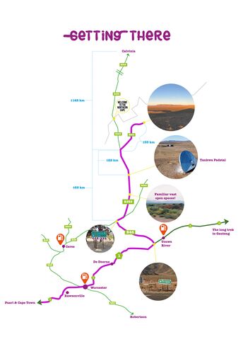
FROM CAPE TOWN
Aweh! Rad you could make it bru!
Take the N1 North, passing Paarl, Worcester and De Doorns. 10km before you reach Touwsrivier, 160km from Cape Town, take the LEFT onto the R46, towards Ceres. If you need to fill up on fuel, do so – Worcester or Touwsrivier are your last chances.
This road continues for approximately 40km and ends in a T-junction. At the T-junction turn RIGHT onto the tyre-munching R355 towards Calvinia and Sutherland. Approximately 100m on, you’ll hit the dirt.
SLOW DOWN.
You brought a spare wheel, right? Good. Oh, you brought two? Smart move.
This stretch of road is dangerous. Like psycho-pitbull-with-a-hangover dangerous. DO NOT DRIVE AT HIGH SPEED.
It’s a long road - take in the view, read the signs.
Round about now, you lose cellphone signal (did you download a podcast from Radio Free Tankwa?). Switch it off and forget about it. Goodbye telecommunication, hello real communication!
Stay on the R355 towards Calvinia and the Tankwa Padstal, you'll see a giant crashed flying saucer just outside it. The Padstal is a great place to stretch your feet and the last WiFi you'll have for a while. Once you're fully refreshed, get back on the R355 heading north towards the Tankwa Karoo National Park.
About 22km from the Tankwa Padstal, you'll see a turn off to your right, that is also signposted "Tankwa Karoo National Park". Take this turning that heads East towards Quaggafontein.
Continue along this road for about 33km and then the entrance to Quaggafontein (and AfrikaBurn) will be on your right-hand side.
It’s a rough road, so take it easy - you’re nearly there.
As you go through the gate, you’ll come to Die Hek, the gate to Tankwa Town, and Box Office. Here you will be checked in, and your tickets scanned.
Move along to the Greeting Station. Take a deep breath. Step through the portal.
If you’re a Virgin, ring the virgin bell!
WELCOME!
FROM JOHANNESBURG
From Jozi? Huzzit, China!
Take the N1 South to Bloemfontein/Cape Town. Stay on the N1 through Colesburg, Hanover and Richmond.
From Richmond travel 64km on the N1 and turn right onto the R63 to Victoria West. Travel on the R63 through Victoria West and follow the road and signs to Calvinia.
Note: Do not attempt to go via the R354 (Middlepos) road. It is in an extremely bad state and will take you 8 hours to do the 180 km or so to Quaggafontein.
Also take note: This is the last time you will have phone signal until you get back to this spot - this includes at the event.
Calvinia is the last place where you can get supplies (water, gas, petrol, etc.), so if you need them, get them. There are no shops after Calvinia.
Drive through Calvinia and about 2km outside of town you’ll see a sign ‘Ceres R355’. Turn left here onto the gravel road to Ceres. Stick to the R355 until you get the turnoff to the Tankwa Karoo National park (About 50 or so km from the Calvinia side) you will see a board on the roadside saying Calvinia-Ceres - turn left at that turn. This is the shortest road to take, it does have a couple of sections that has been somewhat washed away but it is manageable if you take it slowly.
Do NOT drive faster that 70km per hour under any circumstances, or in any vehicle, at any time along this gravel road!
Continue along this road for about 90km and then the entrance to Quaggafontein (and AfrikaBurn) will be on your left-hand side.
Alternative route 1: Continue to travel carefully along the R355 for approximately 140km. Do not turn off, but rather follow the R355 down past Stonehenge/Tankwa Tented Camp
Watch up ahead for a Junction with a road to the left that is also signposted "Tankwa Karoo National Park". Take this turning that heads East towards Quaggafontein.
Continue along this road for about 33km and then the entrance to Quaggafontein (and AfrikaBurn) will be on your right-hand side. You’re almost there boet!
Alternative route 2: You can also drive all the way down the N1 to Touws River and then turn right back up towards the R355 at Touws River and follow the Cape Town directions. This is the current preferred route for our creative crews from Joburg
Drive about 5km SLOWLY along the entrance road.
Holy crap, you’re close now! Further along you’ll come to Die Hek, our event gate and Box Office
Move along to the Greeting Station. Take a deep breath.
Virgin? Welcome – ring the bell!
VIA BLOEM
Van Bloem af, chomma? Mooi so!
Take the N8 to Kimberley and then continue along the N12 to Victoria West.
Turn right into the R63 at Victoria West (T-junction), thereafter follow the directions listed above for Johannesburg from Victoria West onward.
Again, from Bloem you can also just follow the N1 to Touws River (Alternative route 2).
FROM DURBAN
From Durbs? Hundreds bru!
Take the N3 out of town, and head to Harrismith.
At Harrismith, take the N5 via Bethlehem to Winberg, where you join the N1 and follow this to Bloemfontein.
Thereafter follow the directions listed for Bloemfontein.
Click here for Print Friendly Directions.
Also see: Maps.